Cardiff's Millennium Stadium was built on the site of the old national stadium to host the 1999 Rugby World Cup and is the Welsh national stadium. It hosts both the country's rugby and football matches as well as other events and has a seating capacity of 74,500. It was renamed the Principality Stadium in 2016 for sponsorship reasons. The area around the old stadium was extensively re-developed at the same time, the Millennium River Walk between the stadium and the River Taff was one of the improvements.
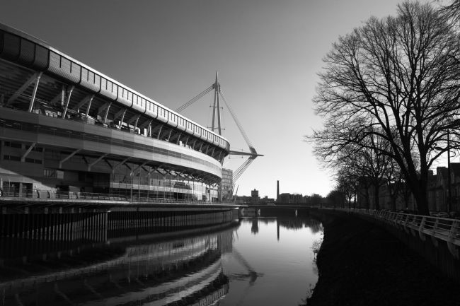
Cardiff's Millennium Stadium was built next to the River Taff on the site of the old national stadium to host the 1999 Rugby World Cup and is the Welsh national stadium. It hosts both the country's rugby and football matches as well as other events and has a seating capacity of 74,500. It was renamed the Principality Stadium in 2016 for sponsorship reasons. A colour version of this image is also available, please message if interested!
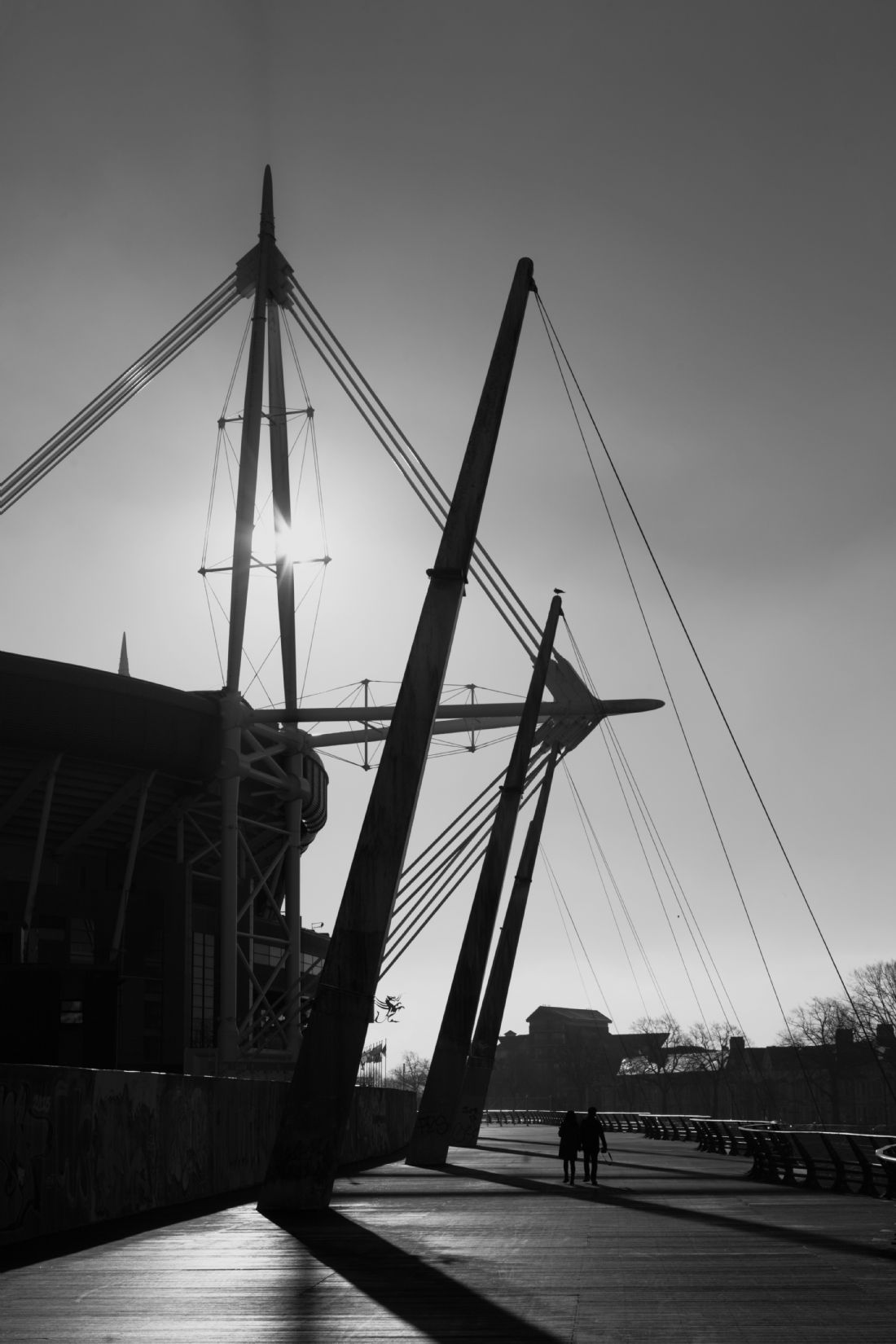
Cardiff's Millennium Stadium (on the left) was built on the site of the old national stadium to host the 1999 Rugby World Cup and is the Welsh national stadium. It hosts both the country's rugby and football matches as well as other events, and was renamed the Principality Stadium in 2016 for sponsorship reasons. The area around the old stadium was extensively re-developed at the same time, the Millennium River Walk between the stadium and the River Taff was one of the improvements. A colour version of this image is also available, please message if interested!
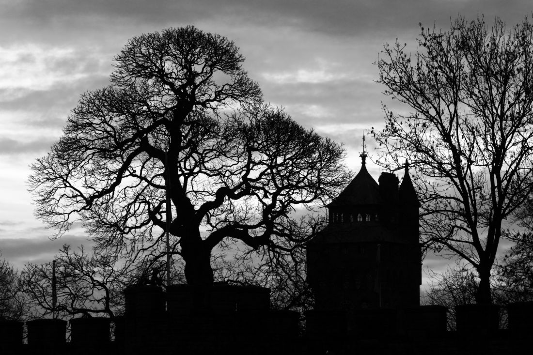
A black and white shot of Cardiff castle and trees in the surrounding Bute Park on a winter's day. Cardiff has had a castle since at least Norman times and the 11th century motte and bailey keep still stands inside the more recent walls and buildings. The Bute family owned the castle and much of the surrounding area from the mid 18th to mid 20th centuries. Construction of the clock tower started in 1868, part of major enlargements in the Gothic Revival style commissioned by the 3rd Marquess of Bute.
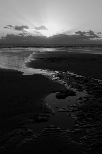
A black and white shot of patterns on the beach at Southerndown Bay in South Wales at sunset. Also known as Dunraven Bay (Bae Dwnrhefn in Welsh), the area is part of the beautiful Glamorgan Heritage Coast and is noted for its dramatic limestone rock formations. The tidal ranges in the Bristol Channel are among the highest in the world (around 13m / 43ft), leaving vast, exposed expanses of beach at low tide.
A gorgeous sunny morning in the hills of South Wales as the clouds clear away after an overnight snowfall. The snow on the fields is just starting to melt in the morning sun while it remains on the higher hills and fells. Trees in winter in Britain have the most amazing shapes and textures, this one is a oak that has been shaped by the strong winds that often blow across the hills.
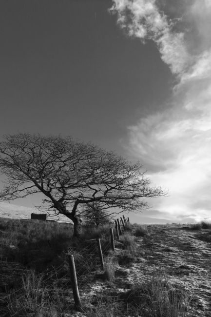
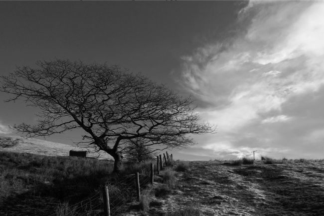
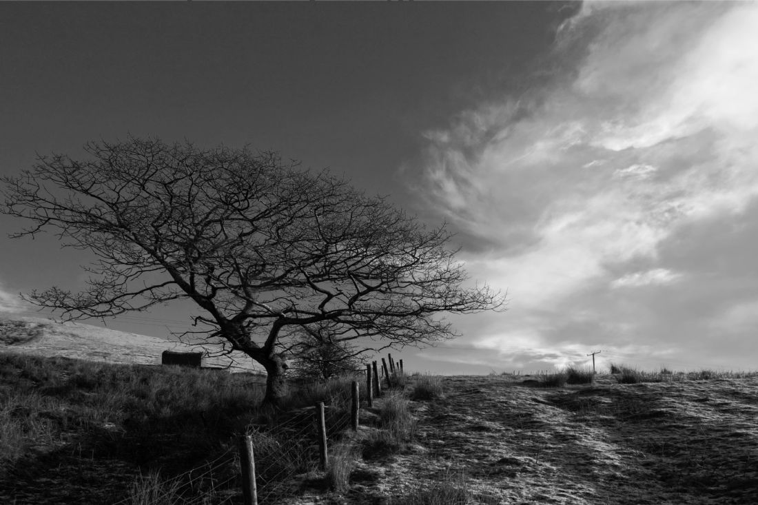
A gorgeous sunny morning in the hills of South Wales as the clouds clear away after an overnight snowfall in black and white. The snow on the fields is just starting to melt in the morning sun while it remains on the higher hills and fells. Trees in winter in Britain have the most amazing shapes and textures, this one is a oak that has been shaped by the strong winds that often blow across the hills.
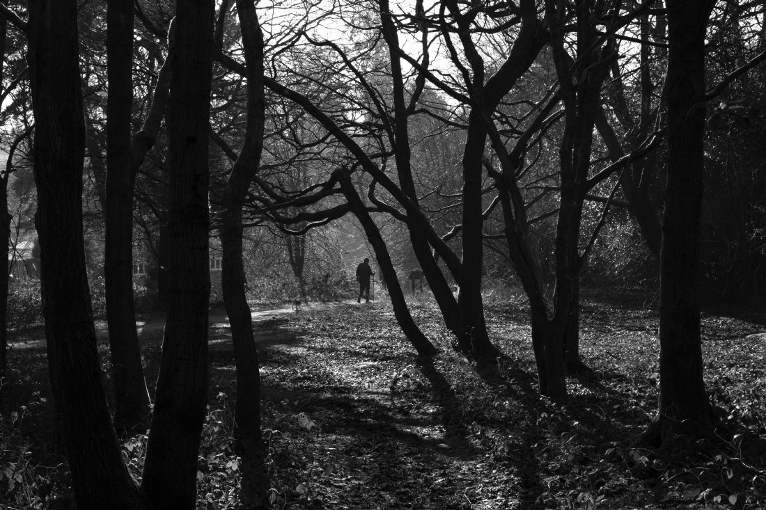
A man and his dog enjoying a walk on the edge of Southborough Common in winter.
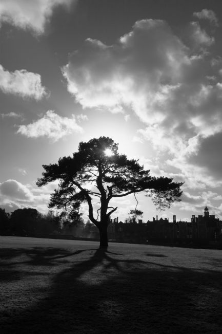
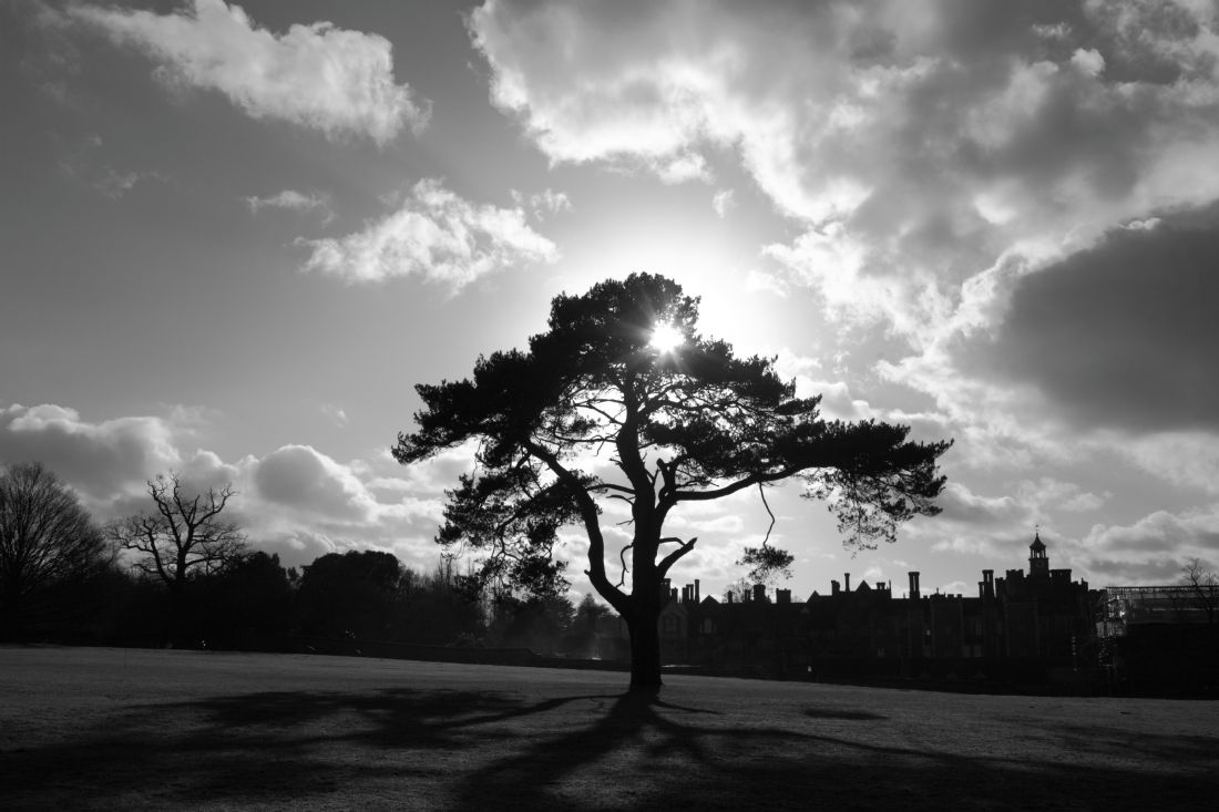
A black and white shot of a backlit pine tree in Knole Park, a deer park just outside Sevenoaks, Kent. Knole House in the background is the largest stately home in Kent and one of the largest in England. The oldest parts date from the 15th century with major expansions in the 16th and especially the early 17th century. The park used to be a popular hunting ground for the English monarchy; now much of it is open to the public and a lovely area for walking.
A black and white shot of a backlit pine tree in Knole Park, a deer park just outside Sevenoaks, Kent. The park used to be a popular hunting ground for the English monarchy; now much of it is open to the public and a lovely area for walking. Knole House in the background is the largest stately home in Kent and one of the largest in England. The oldest parts date from the 15th century with major expansions in the 16th and especially the early 17th century.
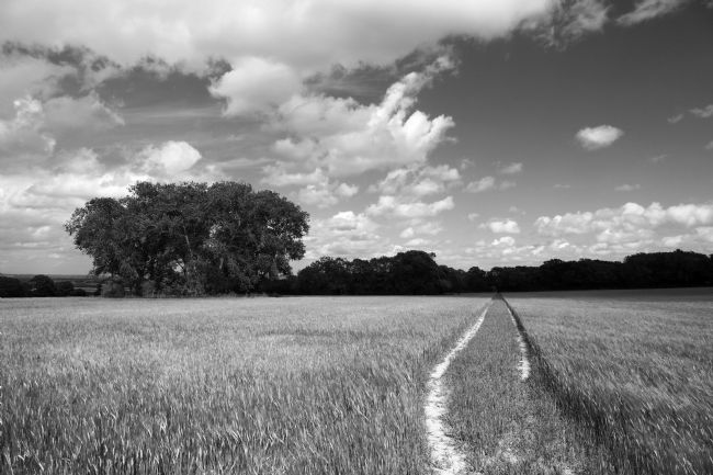
A black and white shot of a typical country scene in the Weald of Kent in early summer, a path through a field of young wheat near the small village of Tudeley. Tudeley lies on the edge of the Medway Valley between Tonbridge and Paddock Wood and the area is still remarkably rural given its proximity to these important railway towns. This may all change in the near future as Tunbridge Wells Borough Council has plans to build over 4,000 new houses on green belt land here which will almost certainly destory its charm and beauty. To find out more about these plans and campaigns against them please visit the Save Capel website: savecapel.com
Facebook Page: savecapel2020
Twitter: SaveCapel
A colour version of this image is also available, please message if you are interested!
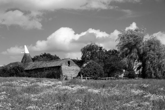
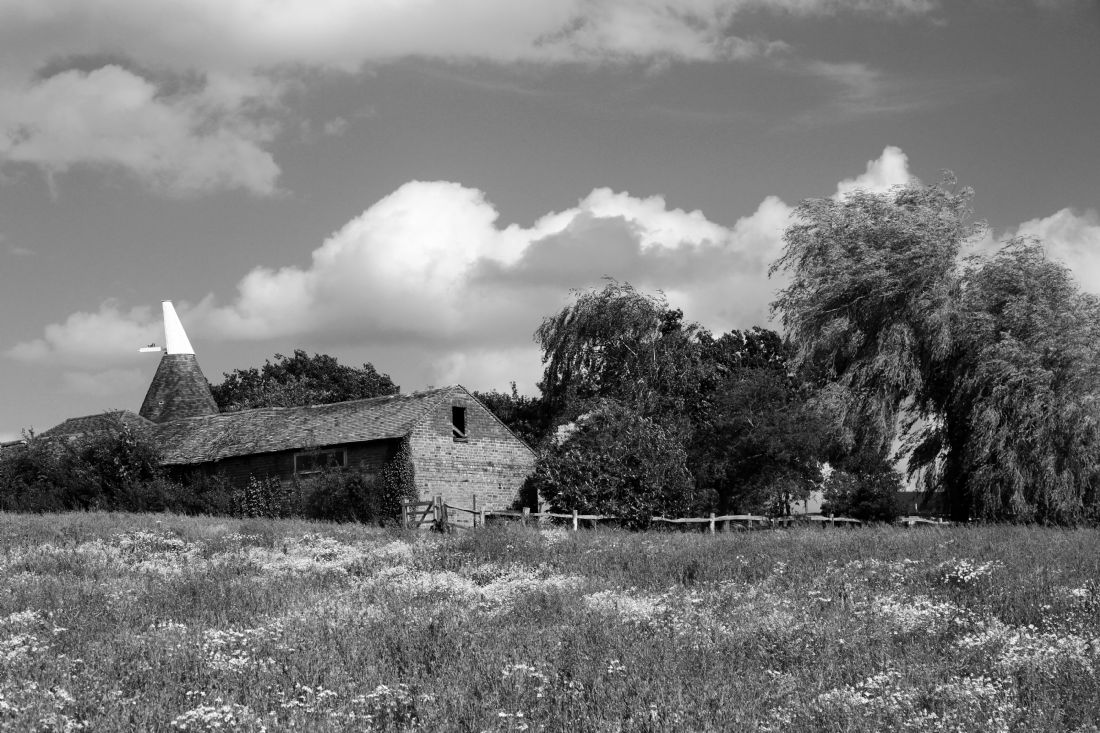
A view in black and white across a wildflower meadow to an oast house, seen from the High Weald Walk near Tudeley, Kent. Oast houses are particularly associated with Kent and are also called hop kilns as they were built to dry hops, once the most important crop in the county. The Tudeley area is still very rural with plenty of beautiful countryside under wide open skies. This may all change in the near future as Tunbridge Wells Borough Council has plans to build over 4,000 new houses on green belt land here which will almost certainly destory its charm and beauty. To find out more about these plans and campaigns against them please visit the Save Capel website: savecapel.com
Facebook Page: savecapel2020
Twitter: SaveCapel
A view over a field of young wheat in early summer near the small hamlet of Capel in the Weald of Kent. A colour version of this image is also available, please message if interested! Capel lies on the edge of the Medway Valley and has long been an important agricultural area. Despite being close to the important railway towns of Tonbridge and Paddock Wood it is still very rural and it is easy to enjoy peace and quiet in picturesque countryside under wide open skies. This may all change in the near future as Tunbridge Wells Borough Council has plans to build over 4,000 new houses nearby on green belt land which will almost certainly destroy its charm and beauty. To find out more about these plans and campaigns against them please visit the Save Capel website: savecapel.com
Facebook: savecapel2020
Twitter: SaveCapel
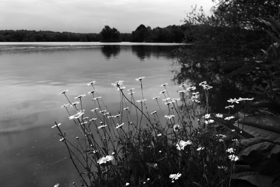
A black and white image of a group of ox-eye / oxeye daisies (Leucanthemum vulgare) in flower on the shore of Haysden Water, a large lake that is part of Haysden Country Park, Kent. The lake lies next to the River Medway just upstream of the Leigh flood barrier, which protects nearby Tonbridge from flooding. It is a popular area for outdoor recreation including fishing and sailing.
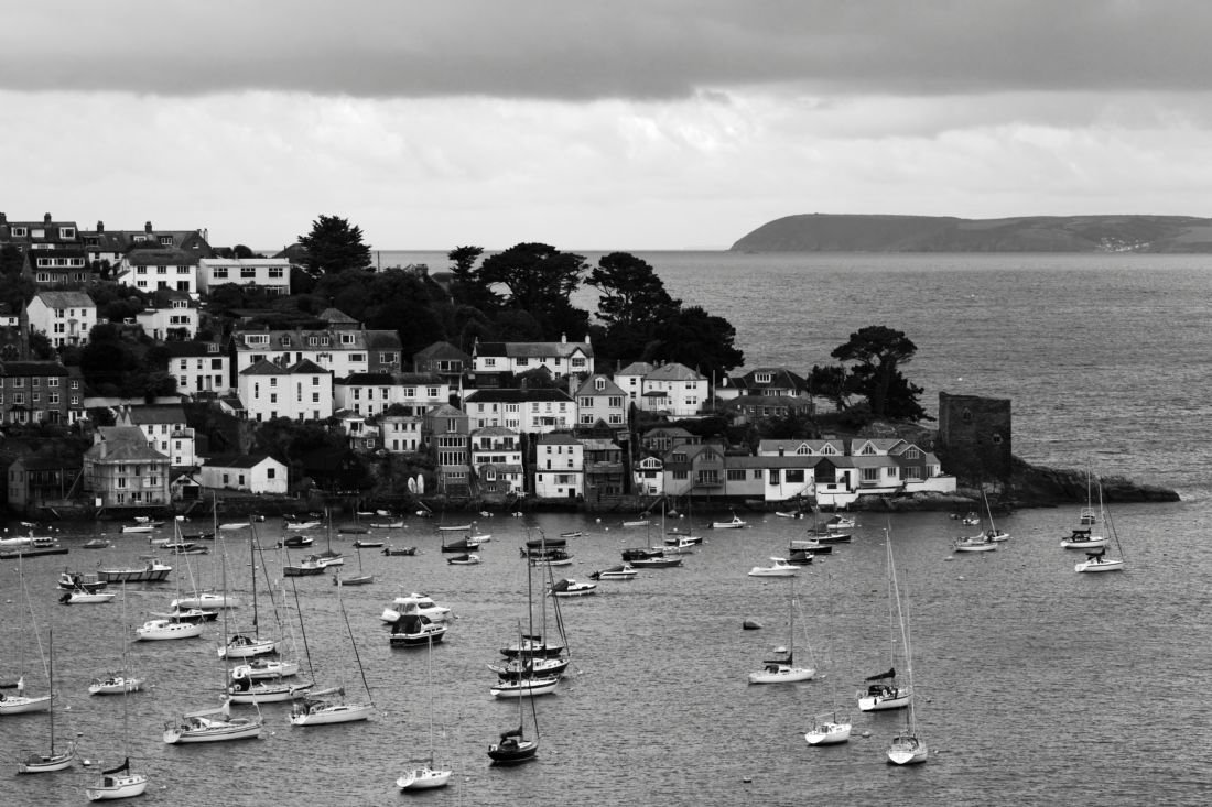
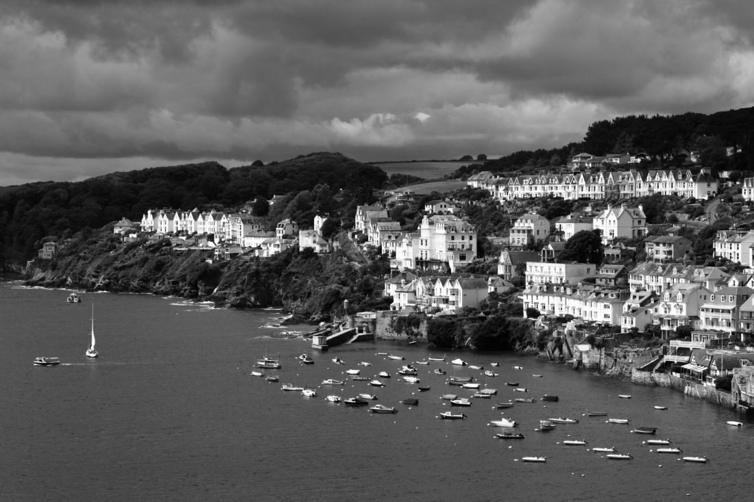
A black and white view of the quaint fishing village of Polruan on the River Fowey estuary on the south Cornwall coast. It lies opposite the historic town of Fowey, both have long been important ports as the estuary forms a superb natural harbour in the rugged coastline. The castle on the end of the promontory dates from the 14th century, Dodman Point is the headland on the horizon.
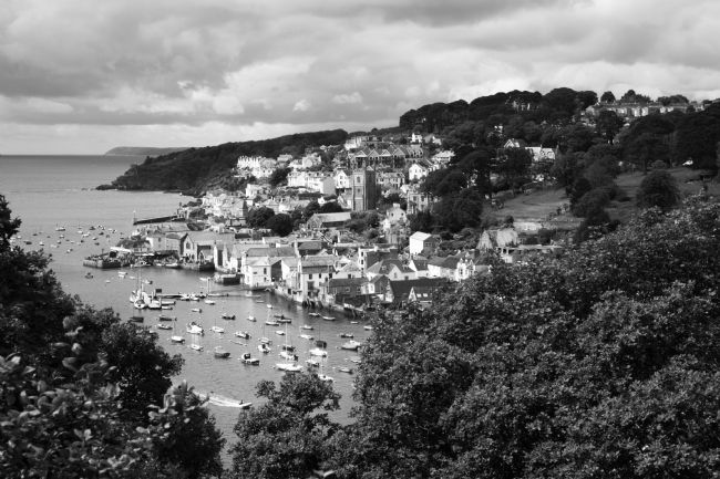
A black and white view of Fowey on the south Cornwall coast, taken from the popular Hall Walk footpath. Fowey is a historic town situated on the River Fowey estuary. It has long been an important port, the estuary offers shelter in a superb natural harbour in a rugged coastline.
A view of the southern part of Fowey on the south Cornwall coast. Fowey is a historic port town located on the River Fowey estuary. It has long been an important port, the estuary forms a superb natural harbour in the otherwise rugged coastline. Colour version also available, please send a message if you would like to see it uploaded!
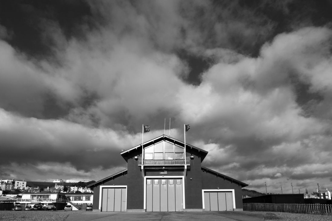
There has been a Lifeboat Station at Hastings, East Sussex since 1858. The current boathouse, which is next to the area of beach used by the local fishing fleet, was built in 1995.
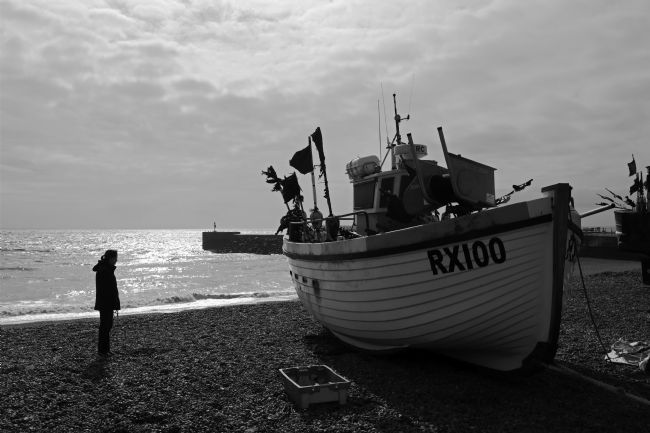
A lady waits for her dog next to a fishing boat on The Stade at Hastings, East Sussex. Hastings is home to one of Britain's oldest fishing fleets and the largest beach (as opposed to harbour) based fishing fleet in Europe. One of the harbour walls (built to provide calmer waters for boats to land on the beach) can be seen in the background
A black and white shot of fishing boats on The Stade at Hastings, East Sussex. Hastings is home to one of Britain's oldest fishing fleets and the largest beach (as opposed to harbour) based fishing fleet in Europe.
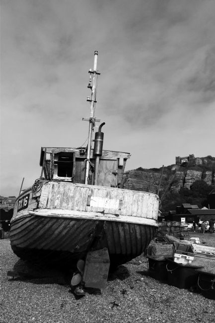
An old wooden fishing boat that is now out of service on The Stade at Hastings, East Sussex. Hastings is home to one of Britain's oldest fishing fleets and the largest beach (as opposed to harbour) based fishing fleet in Europe.
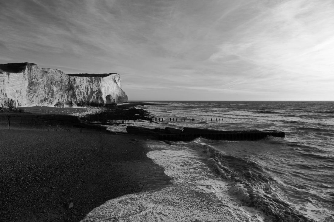
A black and white image of the white cliffs of Seaford Head, to the east of the town of Seaford in East Sussex. It is the westernmost of the chalk headlands that are part of the Seaford to Beachy Head Site of Special Scientific Interest, which also includes the famous Seven Sisters. A colour version of this image is also available, please message if interested!
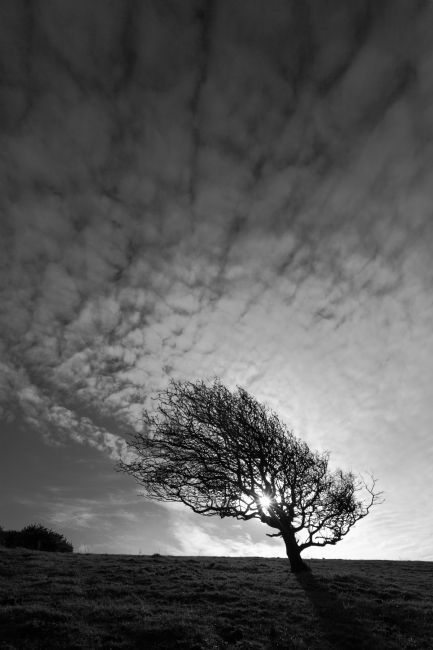
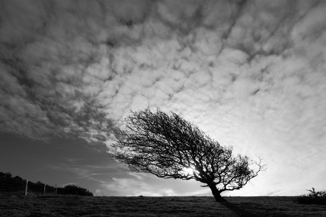
A blackthorn or sloe (Prunus spinosa) tree on the South Downs in East Sussex bent over by prevailing winds. It is common across Europe, its small, black fruit is commonly used to make sloe gin in England, pacharan in the Navarre area of Spain and other alcoholic drinks in other countries. If picked after the first frosts (or frozen after picking, to reduce the bitterness) the fruit can also be used to make jams.
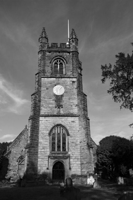
A black and white image of the 15th century Perpendicular style tower of St. Mary the Virgin parish church in Chiddingstone, Kent. A church has stood on the site since Saxon times though most of the current building dates from the14th and 15th centuries. Like many churches in the region it was built using the distinctive local Wealden sandstone.
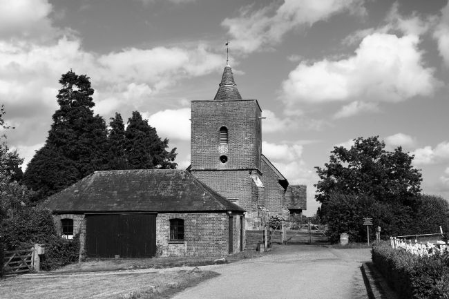
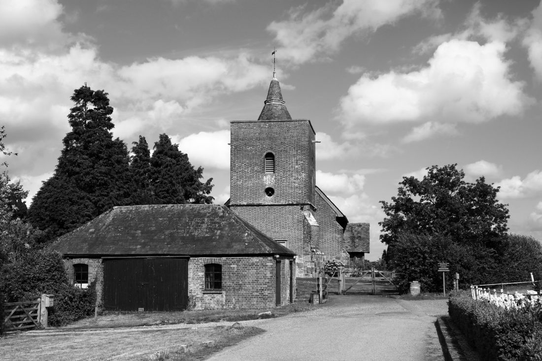
A black and white shot of All Saints church in the small village of Tudeley in the Weald of Kent. There has been a church here since the 7th century, most of the current building dates from the 13th and 14th centuries. The unusual brick tower was added during extensive renovation in the 18th century and contrasts with the Wealden sandstone typical of churches in the Weald. The church is famous for being the only one in the world that has all its stained glass windows designed and installed (between 1967 and 1985) by the Russian-French early modernist artist Marc Chagall. A colour version of this image is also available, please message if interested!
A view in black and white of the unusual brick tower of All Saints church in the small village of Tudeley in the Weald of Kent. There has been a church here since the 7th century, the brickwork is the result of an extensive renovation in the 18th century. The church is famous for being the only one in the world that has all its stained glass windows designed by the Russian-French early modernist artist Marc Chagall. A colour version of this image and similar ones with a closer crop are also available, please message if interested!
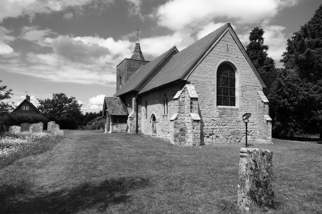
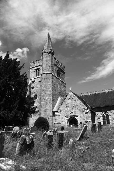
The church of St Mary The Virgin is a short distance outside the village of Lamberhurst, Kent. There was once a church on the site in Saxon times, the current building mainly dates from the 14th and 15th centuries.
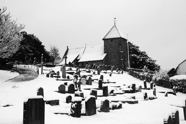
A view of the quaint little St Lawrence Church at Bidborough in the High Weald, Kent after a winter snowfall. The parish of Bidborough is one of the oldest in the area; the church dates from the 11th century.
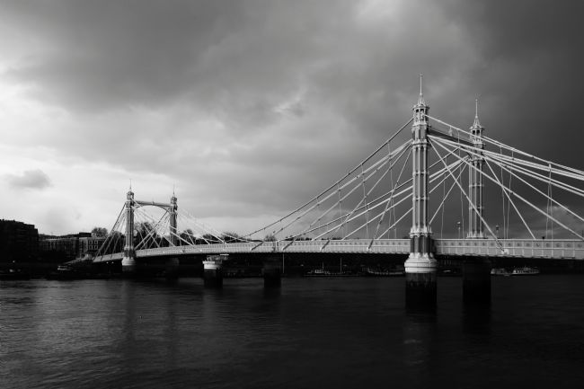
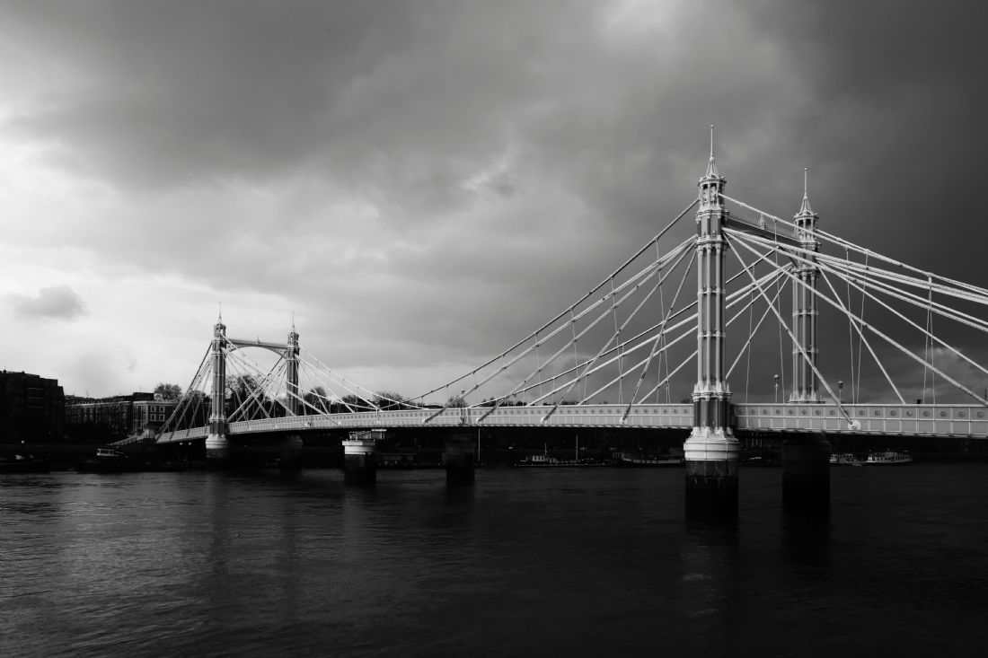
A view of Albert Bridge looking across the River Thames to the North Bank under a stormy sky. Arguably the most elegant bridge across the river in London, it connects Chelsea on the north bank to Battersea on the south. It was designed and built by Rowland Mason Ordish in 1873 as an Ordish–Lefeuvre system cable-stayed bridge, one of only two major bridges built with that system. Structural problems meant it was modified in the 1880s with some suspension bridge elements being added, the problems still continued when motor cars started to appear, meaning that traffic restrictions have been in place for most of its lifetime. The two concrete piers were added in 1973.
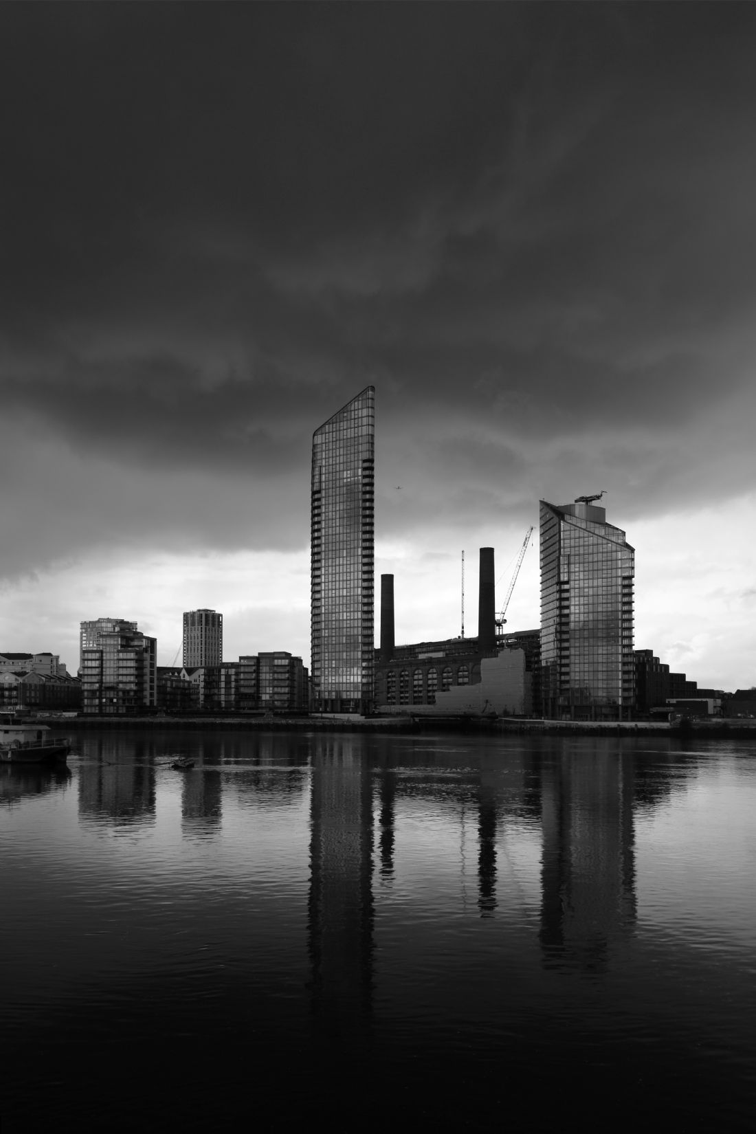
New apartment buildings, part of a huge redevelopment project on the Chelsea Waterfront on the North Bank of the River Thames in central London, under dramatic dark storm clouds. The chimneys between them are part of the Lots Road Power Station, a disused power station which supplied electricity to the London Underground system. It was completed in 1904 and finally shut down in 2002. The power station building is also part of the redevelopment project and due to be converted into shops, restaurants and apartments.
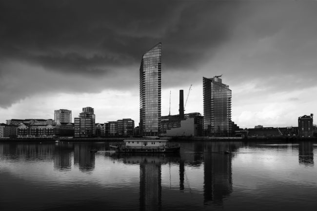
New apartment buildings, part of a huge redevelopment project on the Chelsea Waterfront on the North Bank of the River Thames in central London, under dramatic dark storm clouds. The chimney between them is part of the Lots Road Power Station, a disused power station which supplied electricity to the London Underground system. It was completed in 1904 and finally shut down in 2002. The power station building is also part of the redevelopment project and due to be converted into shops, restaurants and apartments.
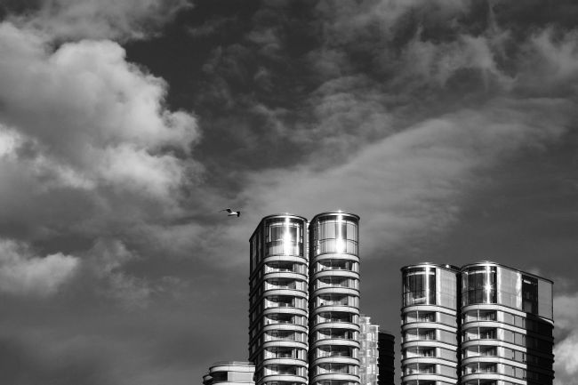
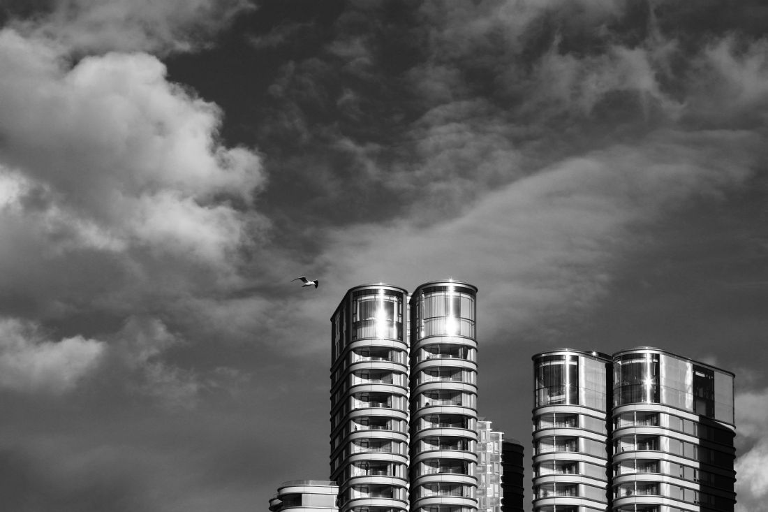
A seagull flies over some of the modern apartment buildings that are part of new redevelopment along the Albert Embankment on the South Bank.
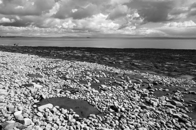
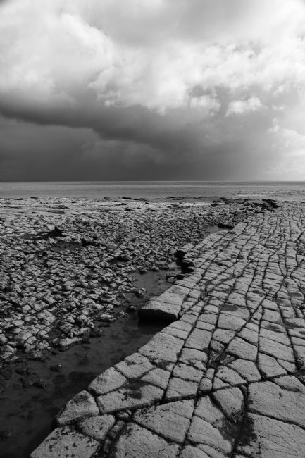
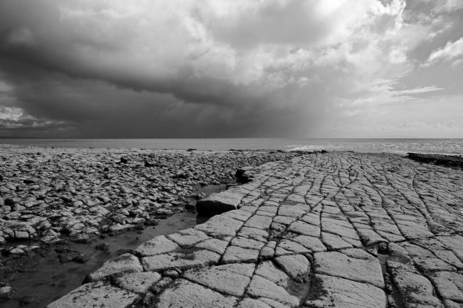
A black and white view of the mudstones and grey limestone pebbles on the foreshore between Penarth and Lavernock Point in South Wales. The area is part of the beautiful Glamorgan Heritage Coast and is famous for its unusual and distinctive geology. Lavernock Point itself marks the lower limit of the Severn estuary and the start of the Bristol Channel; Sand Point in Somerset is the equivalent marker on the southen / English shore.
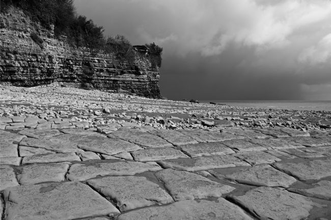
Lavernock Point (Trwyn Larnog in Welsh) lies to the south of Cardiff and Penarth and is part of the beautiful Glamorgan Heritage Coast in South Wales. The Point marks the lower limit of the Severn estuary and the start of the Bristol Channel; Sand Point in Somerset is the equivalent marker on the southen / English shore. The area is famous for its unusual and distinctive geology, this image shows a part of the impressive grey Carboniferous Limestone beds and formations that are exposed at low tide. The cliffs of the Point itself are mainly alternating layers of limestone and mudstones. A colour version of this image is also available, please message if you are interested!
A black and white shot of some of the impressive grey Carboniferous Limestone beds and formations that are exposed at low tide below Lavernock Point in South Wales. Lavernock Point (Trwyn Larnog in Welsh) lies to the south of Cardiff and Penarth and is part of the beautiful Glamorgan Heritage Coast. The Point marks the lower limit of the Severn estuary and the start of the Bristol Channel; Sand Point in Somerset is the equivalent marker on the southen / English shore. The area is famous for its unusual and distinctive geology and is also popular with fossil hunters.
A black and white shot of some of the impressive grey Carboniferous Limestone beds and formations that are exposed at low tide below Lavernock Point in South Wales. Lavernock Point (Trwyn Larnog in Welsh) lies to the south of Cardiff and Penarth and is part of the beautiful Glamorgan Heritage Coast. The Point marks the lower limit of the Severn estuary and the start of the Bristol Channel; Sand Point in Somerset is the equivalent marker on the southen / English shore. The area is famous for its unusual and distinctive geology and is also popular with fossil hunters.
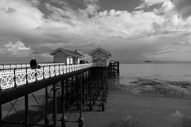
Penarth is a seaside town on the southern end of the Bay of Cardiff that used to be a very popular holiday resort in Victorian times. Its attractive pier opened in 1895 and is 750ft / 230m long. Built mainly of cast iron with wooden decking, it has been damaged several times as the result of ships colliding with it, and underwent a major restoration project in the 1990s.
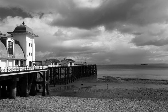
Penarth is a seaside town on the southern end of the Bay of Cardiff that used to be a very popular holiday resort in Victorian times. Its attractive pier opened in 1895 and is 750ft / 230m long. The art deco syle pavilion on the left was a later addition, opening in 1930. A major restoration and refurbishment project was completed in 2013.
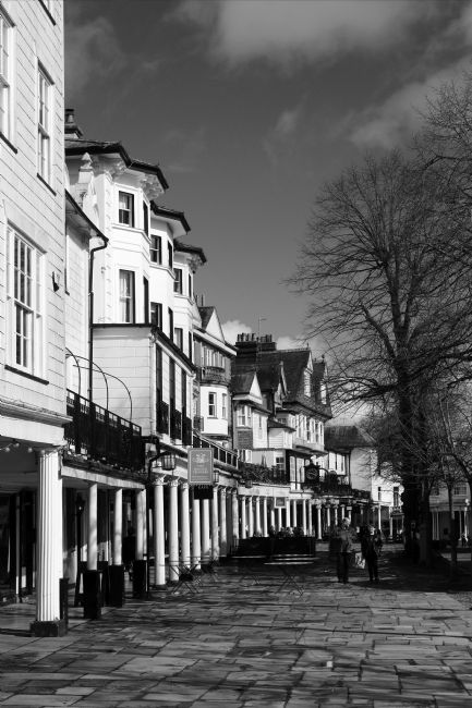
The Pantiles is a beautiful Georgian colonnade and the most famous tourist attraction in Tunbridge Wells. The town owes its existance to the discovery of a chalybeate spring by Dudley Lord North in 1606 at one end of what is now The Pantiles. These rapidly became famous for their supposed healing properties, with visitors including members of the Royal Family. Many of the buildings date from the late 17th century, when the street was redeveloped after a fire in 1687.
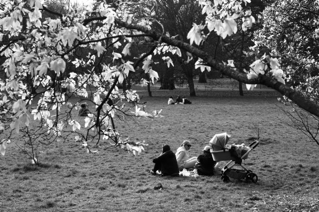
People enjoying the spring sunshine and magnolia blossoms in Bute Park in central Cardiff. The park is named after the Bute family, who owned the nearby castle and much of the surrounding area from the mid 18th to mid 20th centuries.
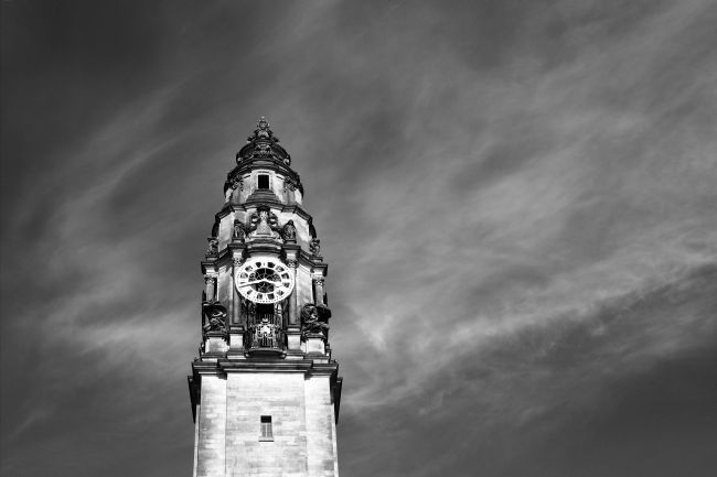
A black and white view of the clock tower of Cardiff's City Hall. The building is an important early example of Edwardian Baroque architecture and and opened in 1906. Cardiff's local city government is based there. The tower is a notable local landmark and 59m /194 ft high.
A blackthorn or sloe (Prunus spinosa) tree on the South Downs in East Sussex bent over by prevailing winds. It is common across Europe, its small, black fruit is commonly used to make sloe gin in England, pacharan in the Navarre area of Spain and other alcoholic drinks in other countries. If picked after the first frosts (or frozen after picking, to reduce the bitterness) the fruit can also be used to make jams.


